Monday, 8 February 2016

Why your geography teachers tell you to stay away from the base of the cliffs on a fieldtrip:

Why your geography teachers tell you to stay away from the base of the cliffs on a fieldtrip:

Friday, 15 May 2015

Formation of a Spit

Here is an example of an explanation of the formation of a spit.
  1. A spit is formed by longshore drift (LSD), when the prevailing wind direction causes swash to push material up the beach at an angle, but backwash moves material back down the beach at 90 degrees.
  2. This causes material to move in a zig-zag fashion.
  3. Where there is a change in direction of the coastline (e.g. a headland or the mouth of a river) LSD continues in the same direction, leading to the deposition of a thin stretch of material extending away from the coastline. This is a spit.
  4. If the wind direction changes, the direction of LSD can change, resulting in a spit with a recurved end.
  5. Salt marshes and mudflats build up in the calm, shallow water behind the spit, and sometimes a lagoon forms.

Note, the formation of a tombolo and a bar can be explained in a similar way, but for a bar, the spit extends until it rejoins the coastline (across a bay or river mouth) and a tombolo develops until it joins an island.

Saturday, 14 March 2015

Dubai - a growth pole

Growth Pole? What's that?

A growth pole is an area of economic growth – i.e. it is becoming richer. It is a place where lots of industries and businesses choose to base themselves, often because they want to be near other industries and businesses that are also there. Governments often try to stimulate growth poles with low tax and other incentives.

Places on the coast have lots of advantages that make them possible growth poles. They may be ports, which attract lots of other industries, they have lots of flat land, which is good for development and they are attractive places to live, which makes it easier for industries to attract the most talented people to live there.

Dubai - a growth pole
Dubai is an excellent example of a growth pole. It has had massive economic growth, lots of businesses and industries have set up there and the government has done lots to stimulate (encourage) this growth.

Where is Dubai? 

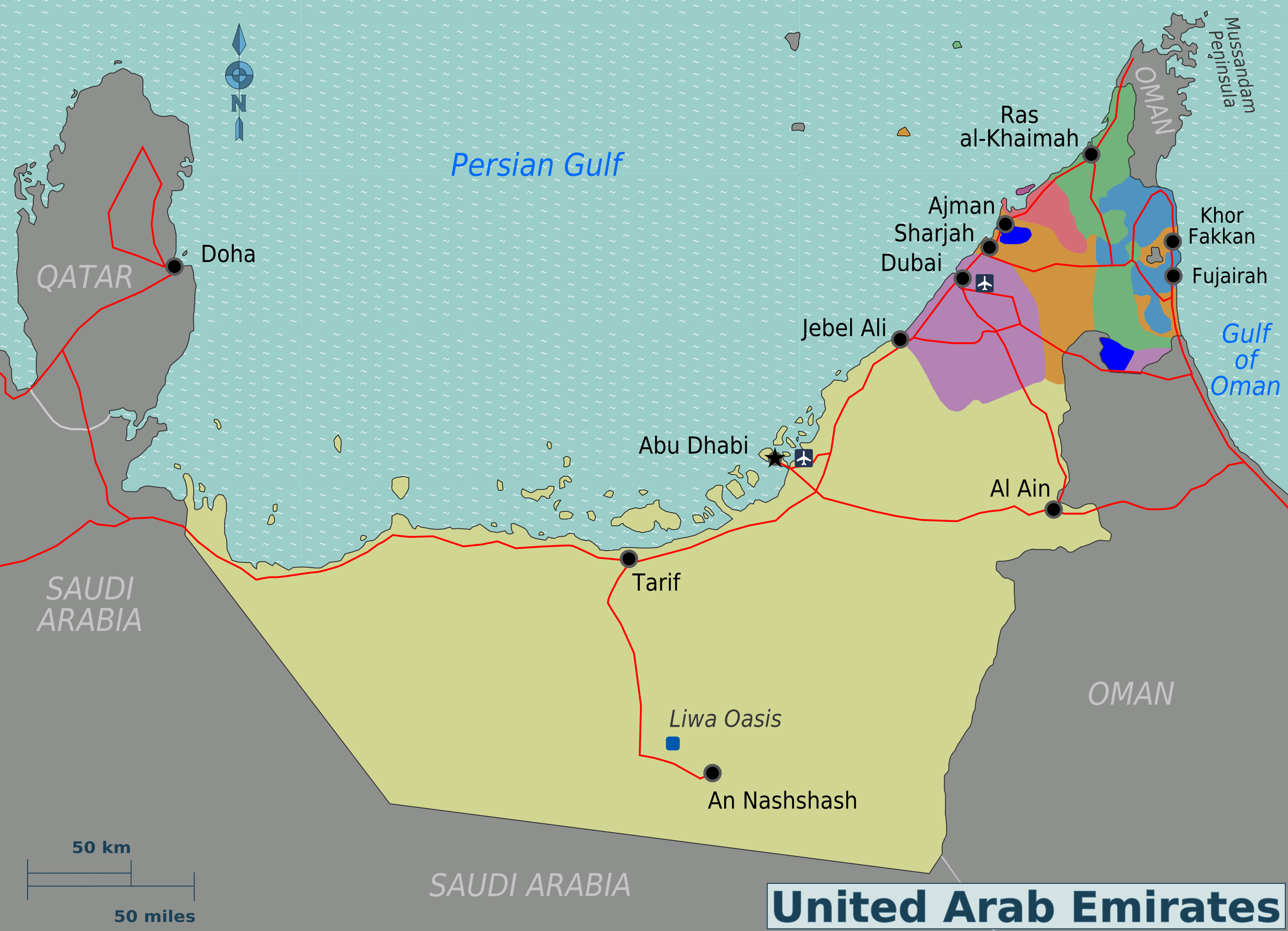
Dubai is one of the seven emirates that makes up the UAE (United Arab Emirates). The UAE is located in the Middle East.

The UAE
Source: By Ksamahi (Own work) [CC-BY-SA-3.0 (http://creativecommons.org/licenses/by-sa/3.0)], via Wikimedia Commons
The Middle East
Source: By Cacahuate, amendments by Globe-trotter and Joelf (Own work based on the blank world map) [CC-BY-SA-3.0-2.5-2.0-1.0 (http://creativecommons.org/licenses/by-sa/3.0)], via Wikimedia Commons
Is Dubai a site of major economic growth?

Dubai was originally a small fishing settlement. Its economy first started to grow in the 1930s with the pearl industry. Then in the late 1950s, the country began to develop its port in an attempt to become a trading hub. When oil was found in the region in the 1960s, it really kickstarted economic growth as the oil was exported, bringing in income, which could be invested in developing the area further.

Dubai Creek in 1964
Source: By Noor Ali ([1]) [Public domain], via Wikimedia Commons

By the 1980s, much of the oil was running out, so Dubai set about finding other ways to generate money. It invested in developing infrastructure, and attacting trade, tourism and industry. This move away from oil has meant that Dubai's economy has kept growing when some of the countries around it have stagnated (slowed down). Today, the UAE has become one of the most developed and wealthiest countries in the world, with a GDP pc of over $64,000.


What evidence is there that Dubai is a growth pole?

So, what has Dubai got?

Infrastructure


Tourism and Real Estate
  • Dubai went from having less than 50 hotels in 1985 to more than 600 in 2014.
  • The '7 star' Burj el Arab, built in 1999
  • Dubailand - a themepark
  • The Palm Island - two man-made islands shaped like palm trees with 3,000 homes and 40 luxury hotels
  • The World - 300 little islands laid out to resemble a map of the world
  • The Burj Dubai - the World's tallest building
  • Dubai attracted 11 million tourists in 2013.
The Burj el Arab
Source: "Burj Al Arab, Dubai, by Joi Ito Dec2007" by Joi Ito  

Shopping
  • Dubai is home to numerous malls, home to brands like Prada, Versace, and Dolce & Gabbana.
  • The Dubai Shopping Festival, held every January and attracting 2 million visitors since 2002.
A Mall in Dubai

Source: By Jagermesh (Own work) [CC BY-SA 3.0 (http://creativecommons.org/licenses/by-sa/3.0)], via Wikimedia Commons

Industry and Business

  • Free trade zones, like Media City and Internet City, that allow businesses to set up with little regulation or taxation. 
  • Internet city has attracted companies such as Hewlett Packard, Dell, IBM, and Sony.


Dubai Media City
Source: Imre Solt [GFDL (http://www.gnu.org/copyleft/fdl.html) or CC-BY-SA-3.0 (http://creativecommons.org/licenses/by-sa/3.0/)], via Wikimedia Commons

How has the government helped Dubai grow? 

As well its major investments in infrastructure, and the creation of tax and employment laws which encourage investment from abroad, the government tolerates western culture such as western dress and alcohol consumption, which attracts people from the US and Europe to live there.


Friday, 19 December 2014

Introducing Ebbsfleet Garden City

Introducing Ebbsfleet Garden City

Help! We need more houses!

Like many cities, the population of London is growing, with the population predicted to reach 9.39 million by the year 2022 and 10 millon by 2030. There are plans to improve the transport system and many areas (such as Kidbrooke and Elephant and Castle) have been redeveloped, but still, more houses will need to be built in order to provide homes for everyone.
New housing developments often lead to conflict. Many people believe that new houses should be built on brownfield land wherever possible, but the government feels that some of London’s new housing will need to be built on the edges of London on greenfield sites.
One of these new housing developments is Ebbsfleet Garden City, announced by the government in March 2014. This will be a brand new urban area in Kent, with 15, 000 homes.

What’s a Garden City?

The idea of Garden Cities was developed in the late 19th century. It was suggested that building self-contained settlements surrounded by greenbelts (fields and woodland) would be better than the development of more and more suburban sprawl.
Garden cities are meant to be sustainable; the buildings should be good quality and there should be green space. Also, there should be jobs and services in the garden city, and not just houses.

Why Ebbsfleet?

Ebbsfleet is near to London, where much of the demand for new housing is. It is close to a high-speed rail line that would mean people living in the new garden city could get to London in less than 20 minutes. It is also close to Ebbsfleet international station, which provides a good connection with France, which should be attractive to businesses that want to trade with and work in mainland Europe. Also, there is a large disused quarry, which is ideal for redeveloping, and Paramount have plans to build a theme park here, which would provide 27,000 jobs.

What will Ebbsfleet Garden City be like?


Although the name suggests one big development, the truth is that Ebbsfleet Garden City (EGC) will be built in stages. The first part of the development is called Castle Hill, and has only 150 homes. It is being built to feel like a ‘Kentish village’, with ‘homes surrounding a neighbourhood garden with grassy areas for children to play, with trees, pathways and public meeting places.’

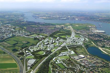
Artist's impression of the Ebbsfleet development. Source: planningresource.co.uk
What is sustainable development?

Sustainable development is defined as 'meeting the needs of the present without compromising the ability of future generations to meet their own needs', and can be imagined as a venn diagram, covering 3 main aspects; social, environmental and economic (see the image below). These are sometimes called the 'pillars' of sustainable development. Where all these pillars are being met, we get sustainability. So, for example, for the needs of people and the environment to be met, development must be bearable for both. For the needs of society to be met as well as the economy, things must be fair (equitable). 

By original: Johann Dréo (talk · contribs) translation: Pro bug catcher (talk · contribs) [GFDL (http://www.gnu.org/copyleft/fdl.html), CC-BY-SA-3.0 (http://creativecommons.org/licenses/by-sa/3.0/), CC BY-SA 2.0 (http://creativecommons.org/licenses/by-sa/2.0) or CC BY-SA 2.0 fr (http://creativecommons.org/licenses/by-sa/2.0/fr/deed.en)], via Wikimedia Commons

Sustainable developments must aim to provide residents with a good quality of life, maintain or improve the quality of the environment and ensure an economy where people have access to good jobs, earning a good wage, and where money is well invested.

Ways that this might be done include:
  • Using efficient and renewable sources of energy, like solar and wind power, biofuels etc.
  • Building energy efficient homes and offices, which are well insulated and well lit, to reduce energy use.
  • Building homes from materials that do as little harm to the environment as possible.
  • Ensuring there are green spaces that benefit wildlife and improve people's quality of life.
  • Making it easy for people to walk and cycle - for example with cycle paths and pedestrian areas  - this benefits the environment and helps improve quality of life.
  • Developing work spaces close to home. This reduces commuting (travel to work and back) which reduces emissions from vehicles, and gives people more leisure time, as they spend less time travelling.
  • Providing services such as schools, healthcare and shops that people can get to quickly and easily, ideally without driving.
  • Ensuring that water is used efficiently, for example collecting rainwater and 'grey' water (water from washing up and bathing) for use in toilets/for watering the garden.
  • Reducing the risk of flooding by having green areas or semi-permeable surfaces that allow water to soak way.
  • Building homes that encourage people to get to know each other, creating a sense of community - homes built around communal areas can do this.
  • Making sure that local people feel involved in the decisions that are made about the area, and preserving local heritage and customs.
These are not the only ways of creating sustainable developments, but they are a good start!

Will EGC be sustainable?

Developers are being encouraged to build sustainably by the government, and the developers of Castle Hill, and the other parts of EGC that are planned mention sustainability in their plans. 

The Castle Hill website describes:

'...the chance to create a place that can give some 'quality time' back to those who choose to live here...[b]y creating a place where all of the things one needs for a pleasant, functioning day-to-day life are in close proximity. This means less time in your car (healthier for all) and more time doing what you want.'

'...recycling where possible...whatever waste the building process creates; office buildings designed to minimise energy consumption; the recycling of water and the reduced need for cars...developing guidelines and standards for our contractors to source construction material in a sustainable manner.' 


'The 150 new homes...will be three and four bedroom family homes. The development includes a range of shops, bars and restaurants and park and leisure facilities.'


The Ebbsfleet Garden City mentions: 

Fasttrack buses 'to promote public transport and reduce the amount of road congestion.' 

'Each area of housing will have its own primary school in a central location that is within walking distance of all houses...Easy access will be provided so that all school children can safely walk to school; parents will not need to drive their children to school.'


'...the Ebbsfleet Education Campus [with] a secondary school and a primary school, both of which will sit in extensive grounds with five football pitch sized playing fields.


The whole campus will be surrounded by trees with a neighbourhood green area on each side.'

Are there any concerns?

Well, you might not know it from some of the press releases, but there is already a town in this area, called Swanscombe. Some of the people who live in Swanscombe have complained that they feel that they have not been consulted. They worry that the name 'Ebbsfleet' have be chosen to erase the historical identity of the place, and that the development will leave Swanscombe poorer, as all the focus will be on the new garden city.


The Campaign to Protect Rural England (a pressure group) argues that it would be better to build on brownfield land (derelict land that has been built on befire, often in cities), rather than develop new garden cities on the greenbelt. This is not as obvious as it might seem, as brownfield site can sometimes be more biodiverse than greenfield ones.

So, do developments like this make Ebbsfleet Garden City a sustainable development? After looking at the plans and reading what the developers and journalists and campaigners have to say, what do you think?


Thursday, 4 December 2014

Flooding Causes Case Studies

Flooding Causes Case Studies
Year 12 generated case studies of the causes of flooding in MEDCs and LEDCs. They are below. Click on them to enlarge.


Boscastle 2004 - DM and HN

Cumbria 2009 - AM, SB and NL

Pakistan 2010 - AS and RT

Somerset 2014 - AI and DBo

Sunday, 21 September 2014

Anatomy of an earthquake

In this short film, Iain Stewart covers some of the main impacts of an earthquake, including factors that can exacerbate damage and casualties. Take note of the importance of where buildings are located.


Well worth 6.45 minutes of your time!

Tuesday, 19 August 2014

Urban Environments - Year 2 GCSE

Urban Environments - Year 2 GCSE

Year 2 GCSE students will be studying Urban Environments after the half term. AQA have this to say in their syllabus:

The world is becoming increasingly urban - it is estimated that by 2020 over 70% of the world's population will live in urban areas. In developing countries large numbers of people are moving to core urban-industrial areas in the hope of improving their quality of life. This rapid urbanisation creates challenges for urban planners in relation to housing and the supply of basic services. In developed countries, many urban areas have gone through a period of economic decline; the challenge in these areas is often about improving socio-economic conditions and addressing environmental issues.
The global future will be an increasingly urban future and this will create a need to put in place sustainable methods of managing urban living in existing areas and designing new urban centres that operate in sympathy with both people and the environment.
The examiners at AQA divide the urban section of the syllabus into 4 key questions:

1. How can urban growth create challenges? 
-  Looking in particular at threats from pollution and the movement of traffic and people.
2. How are inequalities being reduced in urban areas in developed countries? 
- Analysing socio-economic data for trends and patterns, looking at initiatives to reduce inequality and studying examples of urban regeneration.
3. What are the opportunities and challenges created by urbanisation in developing countries?
- Exploring rural-urban migration, economic development, the problems created by rapid urban growth including in squatter settlements and schemes to improve conditions in urban area in the developing world.
4. How can urban living be increasingly sustainable?
- Considering what it means to manage urban areas sustainably and investigating examples of initiatives including carbon neutral housing, greening, recycling and sustainable planning.

If you'd like to do a bit of preparatory reading:

Past papers are here - the urban section will be in the Unit 1 exams

the BBC Bitesize for Urban Environments is here

and Coolgeography also have some Urban resources here

Looking forward to seeing you all back, refreshed, and raring to go!


Tuesday, 15 July 2014

Yellowstone Supervolcano

Yellowstone is in the news again (see here) after a thermal hotspot melted asphalt on one of the roads in the park. Yellowstone is a 'supervolcano' - a volcano capable of producing eruptions that measure VEI8 on the volcanic explosivity index  - 1000 times larger than standard volcanic events.

In 2006, the BBC and Discovery channel produced a drama called 'Supervolcano'. This looked at the possible impact of a massive eruption at Yellowstone. The US Geological Survey described the film as an 'acceptable' attempt to show what might happen in the event of such an eruption.

Geologists say the the current hotspot activity is not an indication of a likely eruption, with Dan Hottle, the park spokesman saying, 'the supervolcano is not going to blow.'
Source: Thomas Moran [Public domain], via Wikimedia Commons

Tuesday, 27 May 2014

Welcome to Folkestone

Why Folkestone?

Folkestone is going to be the site for our fieldwork investigation this year. It is an excellent example of a stretch of coastline managed in a variety of ways. 

When we visit, you will need to think about:

1. Why does the local authority spend money defending Folkestone from the sea?
2. How is Folkestone defended from both erosion and flooding?
3. How effective are the methods used to defend Folkestone?

Where is Folkestone?

As geographers, you should start off by finding out where Folkestone is. Google Maps is a good place to start (see below), but you should make sure you zoom out to get an idea of where Folkestone is in the UK. If you are showing where Folkestone is in your writing, it is a good idea to use different scales of map to show Folkestone in the UK, as well as a map of the local area.

A map of Folkestone

Portions of this page are reproduced from work created and shared by Google and used according to terms described in the Creative Commons 3.0 Attribution License

Who protects Folkestone?

Next, as we are investigating coastal protection, it would be a good idea to find out who protects the coast at Folkestone. As you will know from studying coastal engineering and management in your lessons, defending the coast is expensive, and so lots of agencies (groups) tend to be involved.

Along the coast of Folkestone, the following groups help defend the coast:
How is Folkestone protected?

Using the SMP, these agencies will have decided on one of the options below:

Advance the line (build sea defences in front of those already there)

Hold the line (maintain defences where they are)

Managed Realignment (build defences further back and allow the sea to move inland)

Do nothing (exactly that)

This map shows you what decisions have been made.

The coastline at Folkestone has been protected using both hard engineering and soft engineering methods. When we go to look at these, you will need to know what they are, what they look like and how they work.

Why does Folkestone need protecting?

As you should remember, there are two main reasons for defending the coast:

1. Coastal erosion - The mix of soft clays and greensands along this stretch of coast means erosion has always been a problem (Folkestone lost 5 churches to erosion before the Norman invasion of 1066). It continues to be a problem along the coast at Folkestone, with landslips at Folkestone Warren and Samphire Hoe. Material is also lost from the beaches due to sediment transportation. 

2. Rising sea levels and coastal flooding - The area has some of the homes at greatest risk from flooding in the country. 

You should also remember that the coast will only be defended if it is economically worthwhile. The management of the coast at Folkestone is based on the value and use of the land.

Some images of Folkestone
Source: Penny Mayes [CC-BY-SA-2.0 (http://creativecommons.org/licenses/by-sa/2.0)], via Wikimedia Commons

Photo credit: Sebastian Maier

Tuesday, 13 May 2014

Geography Models to Know

Just a quick post to  flag up  this useful site, full of clear descriptions an diagrams of models we use, particularly at KS4 and 5, including Demographic Transition, Bid-Rent and various urban landuse  models.

Hoyt - a key land-use model
Source: By PNG version: SuzanneKn at en.wikipedia SVG version: Cieran 91 at en.wikipedia (File:Homer hoyt1.png Transferred from en.wikipedia) [Public domain], via Wikimedia Commons
Highly recommended.

Monday, 21 April 2014

Soufriere Marine Management Area

The what?

The Soufriere Marine Management Area, or SMMA for short, is an example of how a fragile coastal environment can be managed. The Soufriere Coast is a stretch of coastline on the west coast of St. Lucia, an island in the Southern Caribbean, approximately 400km north of South America.

St. Lucia (circled, bottom right), in the Caribbean
Source: By Kmusser (Own work, all data from Vector Map.) [CC-BY-SA-3.0 (http://creativecommons.org/licenses/by-sa/3.0)], via Wikimedia Commons
The island of St. Lucia, showing the location of Soufriere
Source: By Burmesedays [CC-BY-SA-3.0 (http://creativecommons.org/licenses/by-sa/3.0)], via Wikimedia Commons
What is the Soufriere Coast like?

The SMMA organisation describes  Soufriere and the region around it as:
"...a picturesque rural town, located on the southwest coast of the island of St. Lucia. This area is remarkable for the richness and diversity of its landscapes and natural resources, including mountains, rainforest, rivers, active volcanism and coral reefs."
The region has a population of just under 8000, and the area's economy is based on a mix of agriculture (farming), fishing and tourism. Tourism has become more and more important, and the region has many resorts and hotels, many of them focussing on diving and yachting to attract tourists.

Soufriere Town
Source: Bgabel at wikivoyage shared [GFDL (http://www.gnu.org/copyleft/fdl.html) or CC-BY-SA-3.0-2.5-2.0-1.0 (http://creativecommons.org/licenses/by-sa/3.0)], via Wikimedia Commons

What is fragile about the Soufriere Coast?

St Lucia is home to a number of coral reefs. Coral reefs are important but fragile ecosystems. They are known as the rainforests of the sea. Like rainforests, they are home to many species of plants and animals. Unfortunately, coral reefs are at risk from human activities such as fishing, farming and diving. They are also badly affected by warming seas caused by global warming. A study in 2008 estimated that 50% of the world's coral reefs had been so badly affected by human activity that they could be dead in 40 years.

Coral reef on the Soufriere Coast
Source: By WRI Staff (Reef 247) [CC-BY-2.0 (http://creativecommons.org/licenses/by/2.0)], via Wikimedia Commons

So what were humans doing to the Soufriere Coast?

In the 1980s and 1990s, it became clear that the coastline was facing a number of problems.

1. The water was becoming less clean (water degradation), putting human health at risk, as well as the coral reefs. Much of this was the result of sewage and waste being dumped directly into the sea.
2. Over-fishing (too many fish being caught) near the shore was reducing the number of fish, harming the fishing industry (no fish = no fishing)  and putting the coral at risk (the fish eat harmful algae from the reef. No fish = more algae).
3. Sedimentation from the land (soil washing into the sea), leading to sediment covering the coral and killing it).
4. Polluted (dirty) beaches.

The damage caused to the beaches and the coral had environmental impacts for plants and animals, but it also had impacts for science - the biodiversity (wide number of plants and animals) of coral reefs makes them key to scientific research - and for tourism.
There were also many conflicts including:

1. Conflicts between commercial dive operators (people making money taking tourists diving) and fishermen over use of the reefs.
2. Conflicts between yacht owners and fishermen when yachts anchored (parked) in fishing areas.
3. Conflicts between fishermen, locals and hotel owners when hotel owners tried to keep access to the beaches for their guests only.

What was the response?   

In 1992, various organisations in St. Lucia, including the National Trust for St. Lucia and the Soufriere Regional Development Foundation (an NGO) got together with the government and USAID to try to:

a. Identify problems and conflicts
b. Map the area and agree on how different sections of coastline should be used
c. Put in place a way of solving conflicts through discussion

This led to the organisations agreeing to tackle four main issues:

1. Controlling the increased yachting along the coast
2. Setting up marine reserves (nature reserves in the sea)
3. Developing fishing
4. Managing pollution

How did they do this?

They zoned the coast. As the map below shows, they divided the coast into different sections, to be used in different ways. The green areas are nature reserves, the pink areas for fishing, the purple areas for yachting and yellow areas to be used by everyone. They also marked particular sites for SCUBA diving (see the key) and for recreation and leisure. This was called the Sourfriere Marine Management Area (SMMA).

A map of the SMMA zoning
Source: allatsea.net

They banned damaging fishing methods and taught the fishermen less damaging fishing techniques. They also provided loans for fishermen to buy boats and equipment so they could fish further out at sea, where they would not damage the coral.

They 'hoovered' up sediment from the corals and they carry out monitoring to check how the coral and fish are doing, and how clean the water is.

Was this successful?

Yes -

  • Monitoring has shown improvements, especially when all the groups in the area have been involved in the planning and been kept informed of what is being done and why.
  • There is some evidence that more fishing is happening away from the corals and out at sea. 
  • Some endangered corals have returned to the coastline.


No -


Sources:
CONFLICT RESOLUTION AND PARTICIPATORY PLANNING: THE CASE OF THE SOUFRIERE MARINE MANAGEMENT AREA http://www.smma.org.lc/Public/Case%20Studies/SMMA%20Case%20Study.pdf
Activities within the Soufriere Marine Management Area http://www.oas.org/dsd/IABIN/Component1/ReefFix/StLucia2010/ReefFix%20Workshop.ppt


Wednesday, 9 April 2014

No or yes to Nuclear?

Who thinks nuclear is a bad idea?

Lots of groups think nuclear is a bad idea, particularly environmental groups. Greenpeace, Friends of the Earth and the Green Party all argue that nuclear power should not be part of the UK's and/or the World's energy mix.

Greenpeace argue that nuclear power is expensive, dangerous and that it takes money away from the development of renewable energy sources.

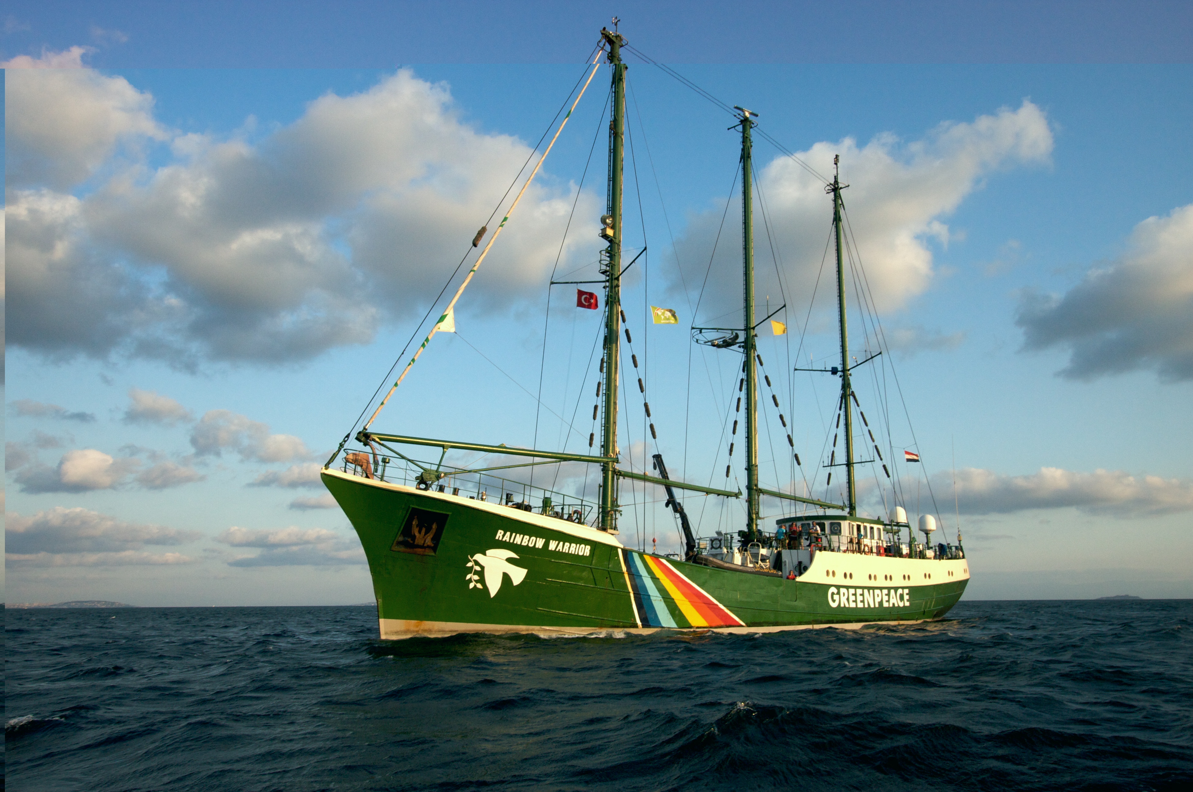
The Greenpeace campaign ship, 'Rainbow Warrior II'
Source: By Salvatore Barbera from Amsterdam, The Netherlands (Rainbow Warrior On The Bosphorus) [CC-BY-SA-2.0 (http://creativecommons.org/licenses/by-sa/2.0)], via Wikimedia Commons
Friends of the Earth say much the same. They also point out that mining and transporting uranium uses a lot of energy, and this means nuclear energy is not 'carbon neutral' (i.e. it does still add carbon dioxide to the atmosphere). Although they considered changing their position and supporting some nuclear power, because they were so concerned about reducing greenhouse gases, the eventually decided to remain opposed to nuclear power completely.

The Green Party also argues against nuclear. Caroline Lucas, a Green Party MP said,
"If we were to make a serious investment in energy efficiency, properly capitalise a Green Investment Bank that would be allowed to lend immediately, put billions into, for example, a street-by-street insulation programme, or really invest in renewables, we wouldn't need nuclear. "
And who supports it?

Mark Lynas is a journalist and environmental campaigner who believes that nuclear power should be used if it will help reduce greenhouse gases. He has written a lot about global warming and believes that reducing the risk of future global warming should be the focus of developing energy sources in future. You can here him debate his ideas with Jenny Jones, leader of the Green Party, here.

The UK government support using nuclear power in our future energy mix. They believe it will help reduce greenhouse gas emissions AND that it will make energy cheaper. Although they think renewables should be the source of much of our energy, they do not think that we will be able to develop them quickly enough for them to replace fossil fuels and nuclear completely. They also believe it will create jobs in the nuclear industry for UK workers. They have recently given permission for EDF, an energy company, to build a new nuclear reactor at Hinkley Point, in Somerset.

Artists impression of the proposed nuclear plant at Hinkley Point
Source: askjaenergy.org
To add to this, groups that lobby for and support the nuclear industry, such as the Canadian Nuclear Association, argue that even with renewables fully developed, there would still be the need for back up energy and that nuclear is the best option for this. 
 
So, what to think?
 
As you can see, the arguments for and against nuclear power are complex. Deciding on whether nuclear should be part of our future energy mix depends on whether you think renewables can be developed quickly enough, whether they can be used everywhere and on how you view the risks associated with nuclear power. Even the experts disagree, but you should use all you have found out to think about where you stand.


Tuesday, 8 April 2014

Renewable pros and cons

So, about these pros and cons?

Yes. As we said before, to decide what energy sources we should use in the future, we need to know the advantages and disadvantages of each. That way we can decide what would be best - and remember, that is likely to include a mix of energy sources, not just one.

Hydroelectric Power, Hydro or HEP

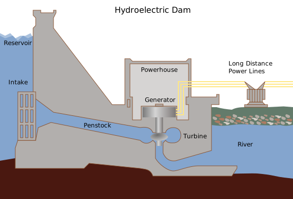
HEP works by using water stored behind a dam to turn turbines and generate electricity.

A diagram of a HEP plant
Source: By Tomia (Own work) [GFDL (http://www.gnu.org/copyleft/fdl.html), CC-BY-SA-3.0 (http://creativecommons.org/licenses/by-sa/3.0/) or CC-BY-2.5 (http://creativecommons.org/licenses/by/2.5)], via Wikimedia Commons

HEP is currently the most used renewable source of electricity, producing just over 15.3% of the World's electricity in 2011.


Source: Jonathan Vizcarra, Quantum Day
 Advantages

HEP is clean (no burning fossil fuels), cheap (once the dam is constructed), reliable (electricity can be produced day and night, all year) and it is a technology we are familiar with. The first HEP plant was built in 1895.

Disadvantages

The major disadvantages of HEP are:
1) The social and environmental impacts cause by flooding large areas of land behind a dam.
2) The need for suitable sites.

Wind Power

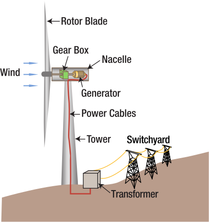
Wind turbines work by using the wind to turn turbines to generate electricity.

A diagram of a wind turbine
Source: By Tennessee Valley Authority (tva.com) [Public domain], via Wikimedia Commons

In the UK, onshore wind power (i.e. wind farms build on the land, not out to sea) is one of the cheapest sources of renewable energy. Offshore wind farms are becoming more common, as they have less impact on the landscape, but they are harder to build and so are a more expensive option. However, offshore wind may be the best option in areas where there is not a lot of space for large onshore wind farms.

An offshore windfarm in Sweden
Source: By © 2011 by Tomasz Sienicki [user: tsca, mail: tomasz.sienicki at gmail.com] (Photograph by Tomasz Sienicki (Own work)) [GFDL (http://www.gnu.org/copyleft/fdl.html) or CC-BY-3.0 (http://creativecommons.org/licenses/by/3.0)], via Wikimedia Commons
 Advantages

Like HEP, wind power is clean (no burning fossil fuels) and once the wind turbines are built, there are no fuel costs as wind is free!

Disadvantages

The major disadvantages of wind power are:
1) The impact of turbines on the landscape (visual and noise pollution) mean people may not want them located nearby.
2) Turbines only generate energy when the wind is blowing - and this is not always when the energy is needed.
3) To generate the amount of energy produced by a power station takes a lot of space (12 power stations = 30,00 wind turbines according to the UK government).

Solar Power

Solar power is produced using  PV (photovoltaic) cells. These cells are able to convert the sun's light into electricity.

Solar panels can be used on a small scale (for example on the roofs of individual buildings), or on a large scale, in 'solar farms'. In 2013, Abu Dhabi opened the largest ever 'concentrated' solar power plant, which uses mirrors to increase the amount of sun's energy that gets to the PV cells and so the amount of electricity produced.

An example of concentrated solar power, in Spain
Source: By afloresm (SOLUCAR PS10) [CC-BY-2.0 (http://creativecommons.org/licenses/by/2.0)], via Wikimedia Commons

 Advantages

Solar power, like HEP and wind power, does not produce greenhouse gases and has no fuel cost. It can be used at a variety of scales, from individual homes to large scale farms and as the technology develops, PV cells are becoming cheaper, making solar power more affordable.

Disadvantages

The major disadvantages of solar are:
1) There are obviously places that solar power is better suited to. So far, the biggest solar farms have been built in places with hot, sunny climates (like Abu Dhabi and Spain), that get a lot of sun throughout the year. As the map below shows, some places receive much more solar energy than others.

Map to show solar energy across Europe
SolarGIS © 2011 GeoModel Solar s.r.o. [CC-BY-SA-3.0 (http://creativecommons.org/licenses/by-sa/3.0)], via Wikimedia Commons

2) Solar panels take up a lot of space - if used in farms, they are best suited to areas that can't be used for other things and where they won't harm natural habitats. There are suggestions to use the tops of roofs to harvest solar energy, as these are often 'wasted' space.

Other Renewable Sources

There are a number of other renewable sources, including wave power, tidal power, biomass and geothermal energy - you can find out about the advantages and disadvantages of these here and here.

So, are renewables the future?

Renewables definitely have to be part of the future - apart from anything else, it seem silly not to use these 'free' sources of energy when people are so worried about energy costs. However, the technologies for many of them will have to be improved if they are to produce enough energy cheaply enough. Also, where they are used needs to be thought about carefully so that they do not have unacceptable social and environmental effects. Whether this can be done quickly enough for us to reduce our reliance on fossil fuels is debatable.